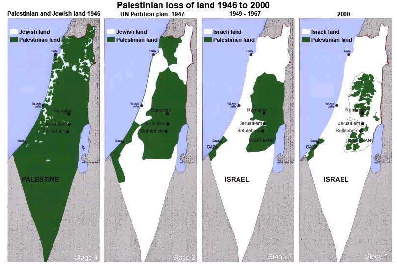
So here's a map of Palestine and Israel over time.

The first panel shows Palestine after World War II, but before the state of Israel was formed.
In the second panel, you see the beginnings of a two state solution - and also why it was not an appealing option for Palestinians.
The third panel is what i thought of when I heard Israel and Palestine. The West Bank and Gaza clearly distinguished from Israel. Small, but independent.
What you see in the fourth panel is the isolated pockets of Palestinians throughout Gaza and the West Bank, with Israeli settlements and military control in between.
Several different tactics create this disconnectedness.
The wall:
Israel is building a 430 mile long wall around Palestine. The barrier is mostly cutting into Palestinian territory, and has cut through families, disconnected farmers from their land, children from their schools, communities from health care providers, etc. It is considered illegal and inhumane by the United Nations, Red Cross, Amnesty International, Human Rights Watch, and (ostensibly) our allies.
I mentioned the tear gas canisters with Jamestown Pennsylvania etched on the side. This comes from a facility with the US and Israeli flags flying side by side. Yearly, our nation gives Israel 3 billion dollars in direct aid and at least 13 billion dollars in indirect aid, such as donated military equipment and loan guarantees.
Areas A, B, and C:
Even with the establishment of a two state solution, Palestine was not given a state. They were given small pieces and told that, with proper management, they could gain more autonomy. Control would come in two parts: Security (policing, intelligence, security), and Social (education, health care, building permits).
Palestine is divided into areas A, B, and C. In area A, Palestinians have both arms of control (security and social) . In areas B, they only have control of the social aspects. Over 60% of Palestine is Area C, where Palestinians have no control.

Military Zones:
Eighteen percent of the West Bank land is considered a military zone. Entrance into these zones by Palestinians is strictly forbidden. Palestinians have no legal process to establish their right to this land - they are forced to evacuate as the Israeli military intends to use it for training.

Nature Reserves:
Ten percent of the West Bank land is an Israeli classified nature preserve. This area is guarded by the Green Police. Coincidentally, these areas are often former grazing areas for shepherds. It is a war against the people's livelihoods. If shepherds are found there, they are fined 1,000 shekels ($300 US) per sheep.


Seam Zones:
Then there are the places in between. People's homes, stuck in the middle of walls and zones and barriers. Eight thousand Palestinians live in these closed areas.
And resources in Palestinian land is considered Israeli. Water, for example, comes largely from Palestine, though Israel controls it. A Palestinian street may run out of water, but that would never happen, literally a street over, in Israel.

Settlements and areas of planned expansion:
Even though it is Palestinian territory, Israeli's move there constantly. There are huge economic incentives, and many believe it is their right. When I say settlements, I do not mean small towns. These are large cities that cut between Palestinian communities. The commute from Bethlehem to Jerusalem is much longer because a settlement started along the main highway. Therefore, Palestinians are not allowed to use that road, and must go around this gated and guarded city.
Not only are Palestinians not allowed on their land when a settlement is built there, but they are also not allowed on areas of planned expansion - areas near settlements, where it is anticipated that more Israelis will soon live.

E1:
Now there is talk of an E1 Zone, which will cut through the North and South of the West bank. This sort of divide may mean incredible relocation of those who live in Bethlehem.
It just so happens that the bodies of the three murdered teens were found in an area that would be E1. Settlements have already popped up in this area.
The nation brings Birth Right tours to recruit new citizens to fill the land. We saw a group enjoying pizza and some conversation about "Arabs" the other day. We were very tempted to take one of their boxes of pizza. This began a hilarious conversation (in our minds) about what we might say if we took their pizza. "Well, ok, you can keep three slices. Though the sauce under those three slices is technically ours. And we are going to put our hands all over it. You absolutely cannot eat the pepperoni though - environmental reasons.And I'm afraid the olives are also off limit - I need a little more practice eating olives. No, no, no, this was never your pizza."
The first panel shows Palestine after World War II, but before the state of Israel was formed.
In the second panel, you see the beginnings of a two state solution - and also why it was not an appealing option for Palestinians.
The third panel is what i thought of when I heard Israel and Palestine. The West Bank and Gaza clearly distinguished from Israel. Small, but independent.
What you see in the fourth panel is the isolated pockets of Palestinians throughout Gaza and the West Bank, with Israeli settlements and military control in between.
Several different tactics create this disconnectedness.
The wall:
Israel is building a 430 mile long wall around Palestine. The barrier is mostly cutting into Palestinian territory, and has cut through families, disconnected farmers from their land, children from their schools, communities from health care providers, etc. It is considered illegal and inhumane by the United Nations, Red Cross, Amnesty International, Human Rights Watch, and (ostensibly) our allies.
I mentioned the tear gas canisters with Jamestown Pennsylvania etched on the side. This comes from a facility with the US and Israeli flags flying side by side. Yearly, our nation gives Israel 3 billion dollars in direct aid and at least 13 billion dollars in indirect aid, such as donated military equipment and loan guarantees.

Areas A, B, and C:
Even with the establishment of a two state solution, Palestine was not given a state. They were given small pieces and told that, with proper management, they could gain more autonomy. Control would come in two parts: Security (policing, intelligence, security), and Social (education, health care, building permits).
Palestine is divided into areas A, B, and C. In area A, Palestinians have both arms of control (security and social) . In areas B, they only have control of the social aspects. Over 60% of Palestine is Area C, where Palestinians have no control.
Military Zones:
Eighteen percent of the West Bank land is considered a military zone. Entrance into these zones by Palestinians is strictly forbidden. Palestinians have no legal process to establish their right to this land - they are forced to evacuate as the Israeli military intends to use it for training.
Nature Reserves:
Ten percent of the West Bank land is an Israeli classified nature preserve. This area is guarded by the Green Police. Coincidentally, these areas are often former grazing areas for shepherds. It is a war against the people's livelihoods. If shepherds are found there, they are fined 1,000 shekels ($300 US) per sheep.
Closures systems:
Traveling the roads between one town to the next can be extremely difficult, time-intensive, and potentially humiliating. There are check points, where guards are posted to confirm paperwork for travel between locations.
On a bus traveling from Bethlehem to Israel, everyone under a certain age must exit the bus, present their paperwork, and re-board. It is strange to see this happen, as bus loads of Israelis travel through Palestinian land without the same hassle.
In addition to check points there are earth mounds, road gates, road blocks, earth walls, trenches, and road barriers (517 in the West Bank) to restrict movement.
Seam Zones:
Then there are the places in between. People's homes, stuck in the middle of walls and zones and barriers. Eight thousand Palestinians live in these closed areas.
And resources in Palestinian land is considered Israeli. Water, for example, comes largely from Palestine, though Israel controls it. A Palestinian street may run out of water, but that would never happen, literally a street over, in Israel.
Settlements and areas of planned expansion:
Even though it is Palestinian territory, Israeli's move there constantly. There are huge economic incentives, and many believe it is their right. When I say settlements, I do not mean small towns. These are large cities that cut between Palestinian communities. The commute from Bethlehem to Jerusalem is much longer because a settlement started along the main highway. Therefore, Palestinians are not allowed to use that road, and must go around this gated and guarded city.
Not only are Palestinians not allowed on their land when a settlement is built there, but they are also not allowed on areas of planned expansion - areas near settlements, where it is anticipated that more Israelis will soon live.
E1:
Now there is talk of an E1 Zone, which will cut through the North and South of the West bank. This sort of divide may mean incredible relocation of those who live in Bethlehem.
It just so happens that the bodies of the three murdered teens were found in an area that would be E1. Settlements have already popped up in this area.
The nation brings Birth Right tours to recruit new citizens to fill the land. We saw a group enjoying pizza and some conversation about "Arabs" the other day. We were very tempted to take one of their boxes of pizza. This began a hilarious conversation (in our minds) about what we might say if we took their pizza. "Well, ok, you can keep three slices. Though the sauce under those three slices is technically ours. And we are going to put our hands all over it. You absolutely cannot eat the pepperoni though - environmental reasons.And I'm afraid the olives are also off limit - I need a little more practice eating olives. No, no, no, this was never your pizza."
No comments:
Post a Comment